
⚓ HORMUZ MONITOR Maritime Intelligence
Live AIS · Strait of Hormuz · Real-time edge
See every vessel in real time
through the Strait of Hormuz.
Military, tankers, cargo & unknown contacts — live position, speed, heading, MMSI, and more. Stop guessing, start tracking with confidence.
📡 UPGRADE unlocks FULL DATA FIELDS:
🆔 Vessel name
📦 Vessel type
📡 Data source
🔢 MMSI
🗺️ Lat / Lon
💨 Speed (knots)
🧭 Course & Heading
✅ Live refresh every 30–60 sec
🔥 UPGRADE NOW →
✔️ No commitment. Cancel anytime. 7-day data history for annual.
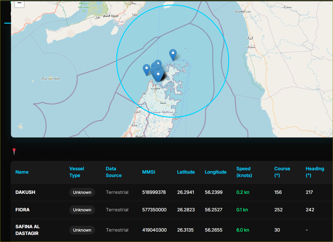
📡 LIVE FEED EXAMPLE (Strait of Hormuz, 18:42 UTC)
Upgraded users see full data →
| Vessel name | Type | MMSI | Latitude | Longitude | Speed(kts) | Course | Heading |
|---|---|---|---|---|---|---|---|
| OCEAN GIANT | Tanker | 636092415 | 26.5342 N | 56.0812 E | 12.4 | 078° | 082° |
| MSC ARIES III | Container | 372849001 | 26.9178 N | 55.9723 E | 18.2 | 112° | 115° |
| B. FREEDOM | Bulk Carrier | 538009387 | 26.0123 N | 56.3221 E | 9.7 | 234° | 230° |
| IRAN HELIX | Patrol | 422567800 | 26.3411 N | 55.8999 E | 23.1 | 044° | 048° |
🔒 Vessel type, source, MMSI, Lat/Lon, speed, course/heading — all visible after upgrade.
Why upgrade from free tier?
- ✅ Real identity: Vessel name, IMO / MMSI + type (tanker, cargo, military, fishing)
- ✅ Predictive awareness: See precise course over ground & heading – avoid surprises
- ✅ Data source transparency: Terrestrial AIS + satellite overlays
- ✅ Low latency tracking: critical for insurance, logistics, security desks
- ✅ Unlimited vessel lookups & alerts (annual plan includes email alerts)
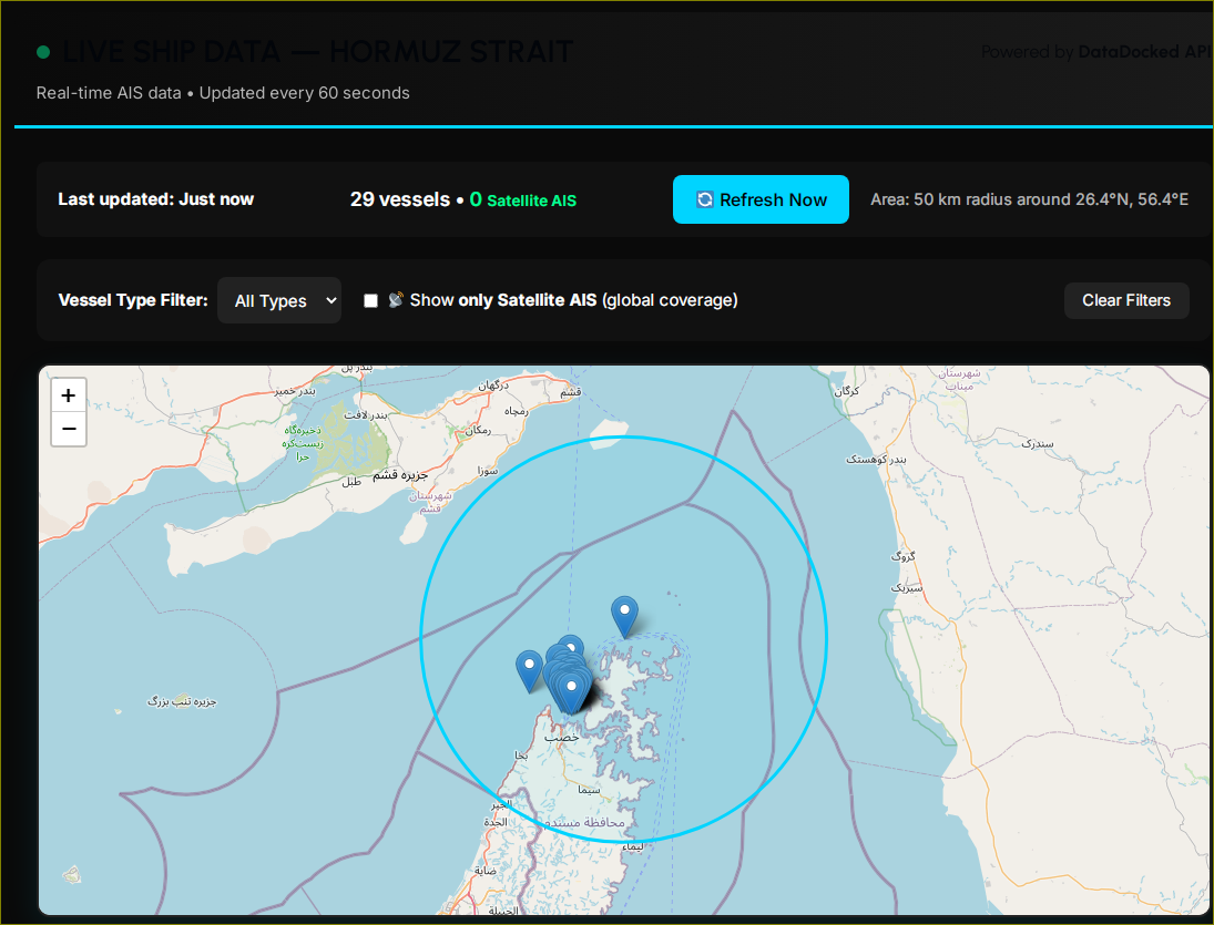
📊 Real-time Strait choke point
Over 20% of global oil passes through Hormuz. Our live data gives insurers, traders, and naval analysts the edge they need.
✔️ Fields available after upgrade: Vessel name, Vessel type, Data source, MMSI, Latitude, Longitude, Speed (knots), Course, Heading.
💎 transparent, mission-ready pricing
🌊 Monthly Access
$112 /month
Billed monthly · cancel anytime
- ✓ Full live ship data (name, type, MMSI, lat/lon, speed, course, heading)
- ✓ Real-time Strait of Hormuz coverage
- ✓ Interactive map & raw data export
🔥 BEST VALUE
⚓ Annual Intelligence
$1,300 /year
Save $44 vs monthly (2 months free!)
- ✓ Everything in Monthly +
- ✓ 30-day historical vessel tracks
- ✓ Priority support & custom alerts (SMS/Webhook)
- ✓ Dedicated account manager for enterprises
- ✓ Advanced filter by vessel type / flag
🛳️ Vessel name & type
Identify tankers, bulk carriers, navy, or fishing vessels immediately.
Identify tankers, bulk carriers, navy, or fishing vessels immediately.
📡 Data source
Terrestrial + Satellite fusion — no blackouts in Hormuz.
Terrestrial + Satellite fusion — no blackouts in Hormuz.
🔢 MMSI number
Unique identifier for every ship, critical for fleet management.
Unique identifier for every ship, critical for fleet management.
📍 Lat/Lon precision
Exact position (DDM format) refreshed every 30 sec.
Exact position (DDM format) refreshed every 30 sec.
💨 Speed (knots)
Detect loitering, drifting, or high-speed transits.
Detect loitering, drifting, or high-speed transits.
🧭 Course & Heading
True motion awareness to predict next port or maneuver.
True motion awareness to predict next port or maneuver.
Don’t navigate the world’s most vital strait with blind spots.
Get live, unredacted AIS data: vessel name, type, MMSI, position, speed, course, heading — instantly on your dashboard.
🚢 UPGRADE NOW🔐 Secure payment · Instant access after registration · Cancel monthly anytime
📡 LIVE DATA FIELDS — guaranteed in your upgraded dashboard:
✓ Vessel name ✓ Vessel type ✓ Data source ✓ MMSI
✓ Latitude ✓ Longitude ✓ Speed (knots) ✓ Course ✓ Heading